Riverside Walk

Norwich’s Riverside Walk offers a peaceful escape in the heart of the city, where scenic views and local character come together along a route full of discoveries.

Quayside, Riverside Walk

As you follow the path beside the River Wensum, you’ll pass 21 landmarks shown on the map below. Each one highlights a different part of Norwich’s story – from historic buildings and bridges to important riverside locations.

Seven of the landmarks are highlighted as Points of Interest, each with an interpretation board and QR code linking to the information shown below.

Map landmarks

Download the map (PDF, 3.9 MB)

Riverside Walk Map
  1. Dolphin Bridge
  2. Train Wood
  3. St Crispin's Bridge
  4. Duke Street
  5. St George's Church, Colegate
  6. Norwich Playhouse
  7. The George's Bridge
  8. Fye Bridge
  9. Whitefriars Bridge
  10. St James Mill
  11. The Great Hospital
  12. Cow Tower
  13. Petch's Corner
  14. Bishop Bridge
  15. Pull’s Ferry
  16. Foundry Bridge
  17. Norwich Railway Station
  18. Dragon Hall
  19. Lady Julian Bridge
  20. Novi Sad Friendship Bridge
  21. Carrow Bridge

Points of interest

We’ve picked out seven points of interest to get you started, though the Riverside Walk has many more hidden gems waiting to be explored.

Anderson’s Meadow

This stretch of river, once known as ‘Back River’, was a popular spot for relaxing. People enjoyed swimming, picnicking, pond-dipping, dyke jumping, fishing and boat trips.

Until the early 1980s, many people flocked to the Back River’s banks and hired boats. ‘Dolphin Boats’ at the Dolphin Ferry was particularly popular.

As the railway line became busier (the Marriott’s Way now follows its old route), there was a growing need to transport people across both the river and the railway.

This was especially true during Norwich’s expansion north into Mile Cross in the 20th century. The Norwich Corporation, (now Norwich City Council) decided a bridge was needed to replace the ferry.

Dolphin Bridge officially opened in 1909. It not only removed the need for hand- punted crossings but also improved safety. This bridge continued over the railway line via a concrete viaduct, meaning pedestrians could cross safely without risking the track-level crossing with its many trains. 

The company hired to build the new bridge, ‘DG Somerville & Co.’, also appears to have built the unique concrete urinal block you’ll see at the next discovery board, near St Crispin’s Bridge.
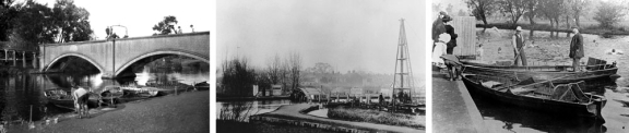
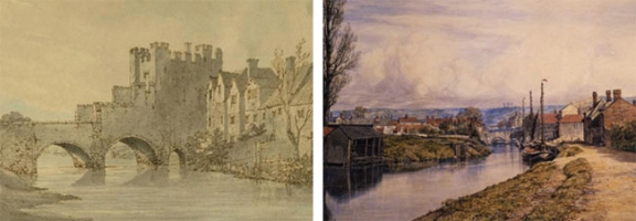
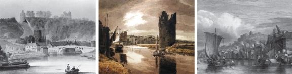
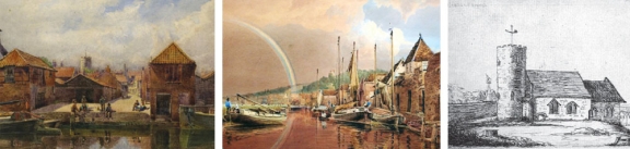
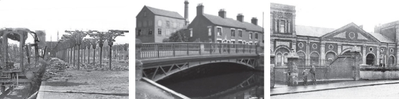
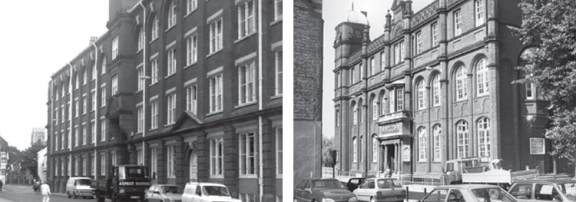
Three Dolphin Bridge images

Photos from left: 

  • Dolphin Bridge (Credit: George Plunkett 1933)
  • The site of Dolphin Ferry as the new Dolphin Bridge is being constructed. The walkway leads to the river from Drayton Road (Credit: Mile Cross Man)
  • Dolphin Boats, before Dolphin Bridge (Credit: Mile Cross Man)

Bishop Bridge

Built between 1337 and 1341, Bishop Bridge is Norwich’s only surviving medieval bridge. Its name comes from leading onto Bishopgate and into The Close, an area directly controlled by Norwich Cathedral.

Made of stone, it was part of the city’s defences and originally had a fortified gatehouse at its outer end. For centuries, it was the main entry point from the east. The carved heads under the bridge’s arches might represent Richard Spink (or Spynk) a wealthy merchant and his wife, who funded the bridge and much of the City Walls.

In 1549, the bridge and its gatehouse were damaged during Kett’s Rebellion. Robert Kett led peasants and landowners against the enclosure of common land. The rebels, camped on Mousehold Heath, fought their way into the city via Bishop Bridge.

By 1790, the gatehouse’s weight was damaging the bridge, causing large cracks in its supporting arches and making the gatehouse lean. It was demolished the following year, leaving the bridge much as it looks today.

Bishop Bridge photos


Photos from left:

  • Bishop Bridge showing the Gatehouse which was demolished in 1791 (J. Farington, 1747-1821)
  • Footpath to Bishop Bridge (J.J. Cotman, 1870)

Credit: Norwich Castle (Norfolk Museum Service)

Bats and birds

The river and bridge are also home to wildlife. At dusk, you might see Pipistrelle bats feeding over the river and nearby bank.

Alongside the swans, the attractive Great-crested Grebe can be seen, and some years ago they began breeding in the city.

Carrow Bridge

From its earliest settlements, Norwich grew on both sides of the river. For centuries, the river was the most reliable way to transport goods, crucial for the city’s trade. However, with the arrival of railways and later cars, the river became less important.

In recent years, riverside activity has seen a revival. Waterside homes are popular, and the riverside paths offer a pleasant route for walkers and cyclists.

Carrow Works is a former industrial site in Norwich that was once home to the renowned condiment producer Colman’s. Spanning 40 acres, the site includes several Grade II listed buildings, along with the Grade I listed Carrow Abbey. With a production history spanning 165 years, Carrow Works is considered a significant part of Norwich’s industrial heritage and has played a key role in shaping the city’s identity.

In 1854, Jeremiah James Coleman moved his family business from Stoke Holy Cross to Carrow. He bought land on the river’s south bank and built up the company that supplied mustard to the world. The site was ideal for rail and river transport, and Norwich provided a large workforce for the expanding factory. By the 1880s, the company employed 2,000 people, and another 4,000 were said to rely on Colman’s for their income.

J.J. Coleman was also a Member of Parliament for many years and helped fund the regional newspaper, the Eastern Daily Press. He lived with his family at Carrow House, on the grounds of Carrow Abbey, a former Benedictine nunnery he bought in 1878.

The two boom towers by Carrow Bridge, connected by a chain, were part of the city walls. Built in the 14th century to defend the city, they were paid for by Richard Spynk, a wealthy merchant.

Carrow Bridge paintings

Photos from left:

  • Old Carrow Bridge (H. Ninham, 1793-1874).
  • Devil's Tower one of the two boom towers (J. Thirtle, 1777-1839).
  • Harrison's Wharf as it appeared in the mid 19th century from a painting by J. Stark.

Credit: Norwich Castle (Norfolk Museum Services)

Lady Julian Bridge

This bridge is named after the medieval mystic ‘Mother Julian’ of Norwich, born in 1342. She was an ‘anchoress’, a religious woman dedicated to prayer who chose to live a solitary life in a confined space called an anchorage. She lived in a cell attached to St. Julian’s Church in King Street and took her name from the church’s patron saint.

She is believed to have arrived at the church in 1373 after experiencing a series of revelations about God’s love during a severe illness. She spent the rest of her life in her cell, devoted to ‘prayer, contemplation, and counselling’, aided only by a servant who did her daily chores. Julian advised people who sought her help, speaking to them through a window in her cell. 

During her time at St. Julian’s, she wrote ‘The Revelations of Divine Love’, an account of her visions or ‘shewings’. It’s the first known book by a woman written in English and is still in print today.

Julian was not Norwich’s only anchoress. Other city churches had cells for them, and it’s believed that other anchoresses used the cell at St. Julian’s Church both before and after her death around 1416.

The Shrine

It’s thought there was a church on the site of St. Julian’s from Anglo-Saxon times, though the current building dates from 1953, when it was almost completely rebuilt after wartime bombing. At this time, the newly discovered foundations of what is believed to be Julian’s Cell (lost centuries after her death) were rebuilt. This allows visitors to make a pilgrimage to this holy place. The Julian Shrine, as it’s known, can be found in St. Julian’s Alley, off King Street, and is part of the Church of Julian.

Lady Julian Bridge photos

Photos from left:

  • Riverside looking north across the river (A. Montague, 1872-1875).
  • Rainbow effect on river at King Street (J. Thirtle, 1817).
  • St Julian's Church (C. Edwards, undated).

Credit: Norwich Castle (Norfolk Museum Service)

Pull’s Ferry

Now a private house, the watergate at Pull’s Ferry was once home to the ferryman it’s named after, John Pull. The arched watergate was built in medieval times, but the adjoining house is newer. It was also known as Sandland’s Ferry, after an earlier ferryman.

Although by 1300 Norwich had five bridges over the River Wensum – more than any other city in England – Bishop Bridge was the only permanent river crossing on the eastern side of the city. This remained true until Carrow and Foundry bridges were built in the early 19th century.

Ferries provided a way for people to cross the river and avoid long detours. Some continued operating even after new bridges were built. A passenger ferry ran from Pull’s Ferry until the 1930s. Many users were spectators heading to The Nest on Rosary Road, then home to Norwich City Football Club.

The canal

The original purpose of the watergate was as the entrance to the canal, where stone to build Norwich Cathedral was brought in. When Herbert de Losinga started work on the cathedral in 1096, this canal was built to link the site to the River Wensum so that stone could be brought by water from Caen in Normandy.

It proved useful as the cathedral took fifty years to complete and used much stone. The canal, which ran beside the current roadway, was subsequently filled in.

Pull's Ferry photos

Photos from left:

  • Pull's Ferry under restoration (G. Plunkett, 1936).
  • Old Foundry Bridge (J.J. Cotman, 1814-1878).
  • Pull's Ferry showing a rowed ferry in use in the early 19th century (Robert Ladbrooke, undated).

Credit: Norwich Castle (Norfolk Museum Service)

St Crispin’s Bridge

The wrought iron St Crispin’s Bridge was built in 1882 to provide access to the new City Station. This station was once located where St Crispin’s Roundabout and Train Wood are now. The bridge was integrated into the inner ring road with a parallel new bridge in the 1970s.

The station, opened in 1882 by the Lynn and Fakenham Railway, later became the southern end of the Midland and Great Northern Joint Railway (MG&N) line from Melton Constable. It became well-used, with services to Cromer and direct carriages to destinations like Peterborough and Leicester.

In 1942, during World War II, the station was bombed, andthe main building was largely destroyed. It continued operating from ‘temporary’ buildings until it closed to passengers in 1959, though it remained in use for goods traffic until 1969.

The ten-sided ferro-concrete toilet block (opposite this board) was for the City Station and installed in 1919. It’s one of only a handful built by the Norwich Corporation (now Norwich City Council) and is the last remaining example of such a structure in the UK. It seems the company hired to build Dolphin Bridge at Anderson’s Meadow was also commissioned to build this unique toilet block, as the ferro-concrete outer walls of Dolphin Bridge match those of the old toilet block. The building has witnessed the city’s changes for over 100 years and was granted Grade II listed status in 1998.

St Crispin's Bridge photos

Photos from left:

  • Norwich train station post 1942 bombing (Jim Lake collection, undated).
  • St Crispin's Bridge (G. Plunkett, 1933).
  • Norwich train station frontage (William Brody c1902).

Credit: Norwich Castle (Norfolk Museum Service)

Norwich Over the Water

The area north of the River Wensum here marks the beginning of ‘Norwich Over the Water’. Originally the name of a medieval district or court, local groups now use it informally to describe the area. It was once home to the textile industry, which was the foundation of the city’s prosperity. As textiles declined, the boot and shoe trade replaced it, becoming Norwich’s most important industry. It employed about 5,470 men and women out of a total working population of 50,000.

Traditionally, footwear was made in small workshops or by shoemakers working from home. The introduction of electricity changed this, and by the early 20th century, shoemaking was largely factory-based.

On St. George’s Street, continuing around the corner into Colegate, stands the former Norvic shoe factory, built in 1876. 

By 1909, it was Britain’s largest shoe factory, with 1,200 workers producing up to 200,000 pairs of shoes each year. The factory closed in the 1970s and was converted into housing and offices.

On the river’s south bank stands the Norwich University College of the Arts. Originally known as the Technical Institute, it was built in 1899 and opened in 1901. This was a time when Norwich was trying to maintain its position as a manufacturing centre and needed a skilled workforce.

St George’s Bridge

The bridge was built in 1748, designed by Sir John Soane, an antiquary and architect of the Bank of England in London.

Described as the ‘most aristocratic bridge in Norwich’, it’s made of Portland stone and has a single span of 42 feet.

It was threatened with demolition in 1930 as part of a road-widening project but was saved after a campaign by the Norwich Society.

Norwich over the Water photos

Photos from left:

  • Former Norvic Shoe Factory (G. Plunkett, 1990).
  • Norwich School of Art, former Technical Institute, built 1899 by architect A.E. Collins (G. Plunkett, 1990).

Credit: Norwich Castle (Norfolk Museum Service)

This wayfinding project was funded by the Greater Norwich Growth Board through the Infrastructure Investment Fund.
 

Norwich City Council, Greater Norwich Development Partnership and The Norwich Society logos
Feedback button